GEOGRAPHY
Ambazonia by virtue of its geographical position in Africa disposes considerable tourist potentials, which make her the place to visit. Ambazonia possesses impressive tourist resources, her relief climate, fauna or flora as well as people and traditions. As home of the highest peak in West Africa and land of the great Menchum Falls, (which scientists say it has the capacity to supply enough electricity to the entire West African Region) Ambazonia offers equally as many traditions as cultural diversities.
Ambazonia is made up of two geographical regions: the Grassland region to the North and the Forest Region to the South. Ambazonia overflows with enormous tourist riches, various natural geographic curiosities, historic vestiges living testimonies of what had existed in the country, a cultural heritage, traditional characteristics of every people that she represent, exhibitions and other folkloric events as varied as its people.
Grassland Region

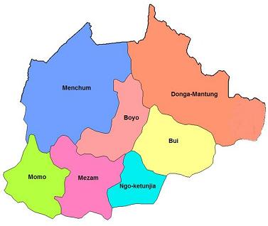
The Grassland Region, located to north of the territory has a population of about 4,750,930 inhabitants with a surface area of 17,300 square kilometers. Its population density is approximated at 98.41 inhabitants per a square kilometer. With seven (7) administrative Counties (Bui, Boyo, Donga-Mantung, Menchum, Mezam, Momo, and Ngo-Kentunjia), the region is hilly & mountainous with beautiful grass-field landscape, variety of traditional palaces, waterfalls, crater lakes, handicraft shops and abundant artifacts which make it the citadel of the nation’s rich culture. Totally neglected by the annexationist colonialist regime of Yaoundé, the Grassland Region has no major industrial plant, and the only relatively flat area is the Ndop Plain where rice is grown. There are equally a variety of languages spoken by its beautiful people. The main languages are Bafmen, Oku, Lamso, Bamenta, Pinyin, Balikumbat, Mankon, Wimbum and Nkom. There are nine hotels, seven restaurants & two night clubs of international standard. Seven large tribes dominate the region: The Nso, Wimbum, Meta, Kom, Esimbi, Oku & Menda-Nkwe people.
Climate
There are two seasons:
A dry season beginning from November and ending around May. The average temperature is about 20°c the air is dry and cold.
A rainy season that begins in June and ends around October. In the day the average temperature is about 20°c and 15°c at night.
Relief
Bamenda is surrounded by several mountainous ranges and deep valleys. The valleys are generally covered by raphia and eucalyptus. Raphia is a basic raw material for the fabrication of art objects. It is also used in the production of raphia wine appreciated by visitors of the region.
Touristic Sites
Mezam County:
- The Awing crater lake
- Press-craft center of Bamenda
- Handicraft center of Bamenda
- Rocky mountain chain of Sabga
- Many small water falls at up station
- The Bafut palace, the Bali palace
- The Bali press craft workshop
- The Mbantu shrine
- Snake research center of Bali
- Cold hill at Bafut
- The German cemetery in Bali
- Salt springs of Sabga
Ngoketunjia County:
- The Baba plain
- The Bamungo palace (one of the most beautiful Chief’s palace), the cradle of all the traditions of the region
- Mount Wainamah, 2, 500m from its peak (the Bamendjon Dam can be observed)
- The Bamessing fish station
- The Bambalang palace
Boyo County:
- The Laikom Palace, 79km from Bamenda
- The German palace, 72km from Bamenda
- The Mbi crater cave and game reserve at Fundong, 78km from Bamenda
- Lake Kuk of Bafmen
- Ejim Trust Reserve of Bello, 45km from Bamenda
Momo County:
- The Abbi waterfalls in Mbengwi
- The Falls of oshie
- The Mbengwi monastery
- The Oshie palace
- The Guzang Fon’s palace
- Itipanghi (Widikum Ancestral Site in Azem Clan)
- Ambelle Boulder
- Gonikob (Scenic rocks in Ngwenjin-Azem Clan)
- Dudum Falls in Akuwu
- Tadkon Historical Site
- Ambelle Ette-Begout Mountain and Caves
- Abebung historical home of Abendong
- Abegum Fon's Palace
Menchum County:
- The Menchum Falls at 65km from Bamenda
- The Kimbi Forest Reserve with its fauna rich in several animal species (antelopes, chimpanzee, gorilla etc)
- Lake Nyos
- Lake Wum (the Silent Lake)
Bui County:
- The Nkar palace
- The Kumbo Cathedral constructed entirely with stones
- The Oku Honey and Handicraft reserve
- The Kum town, built on several hills, a site favorable for curative tourism and for mountain tourism
- Lake Oku
- Kilum Mountain
Donga-Mantung County:
- Binka village situated on the hills about 3,000m high with several cattle ranches
- The Ndu Tea plantation
- The artificial lake of Binshua
- King’s rock of Nwa
- Kwe Athombo cave at Nkambe
- Iron Ore at Nwa
- Binkar landscape and cattle market
- Rom Rocks of Nwa
- Ndu Palace
- Tabenken Valley
- Mbaw plain
Forest Region

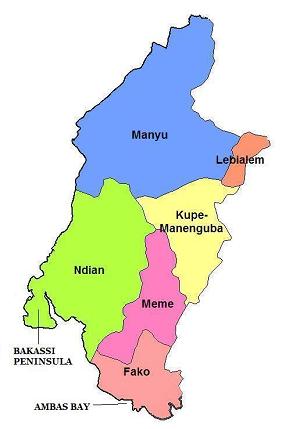
The Forest Region, with a population of about 2,243,125 inhabitants, has a surface area of 25,410 square kilometers. Made up of 6 administrative counties (Fako, Kupe-Manengouba, Manyu, Meme, Ndian, and Lebialem counties) with a total population density of 45.38 inhabitants per a square kilometer, the region is the home of Mount Fako which is the highest mountain in West Africa (with a height of 4,100 meters). With a very rich and attractive colorful coastline with numerous beaches, the Southern Region is the home of the Korup Park, situated in Ndian County and home of a wide variety of trees and rare animals.
Climate:
Relief:
The highest point of the region, and also the highest point in Ambazonia, is Mount Fako (4, 100 m), situated (4°12'N/9°10'E) on the coast. In the mountains along the western border there are two distinct dry seasons. The most important one is short at the coast and increases in severity in passing inland, where it may last for 4 months from November-February, for instance at Mamfe (5°46'N/9°18'E) and Bamenda (5°55'N/10°09'E), where these months are virtually rainless. At Tiko (4°02'N/9°19'E) on the coast, this dry season is much shorter, lasting just two months, December -January. The second dry season is much shorter and is far less severe, but is seen in a sharp diminution of rainfall during June-July, when the monthly totals are in the region of 90-150 mm at all three stations.
The coast enjoys a per-humid equatorial climate. At the coast the border with Nigeria is defined by the course of the small Akpa Yafe River, which reaches the sea through a mangrove swamp 35.5 km deep between landward and seaward faces. This forest block, intersected by the Rio del Rey, Ngosso and Andokat Estuaries, stretches 57 km along the coast until it is interrupted by the slopes of Mount Fako which descend steeply into the sea. This great mangrove block, covering 145 000 hectares, has developed on the deltaic coast created by hundreds of small streams draining the very wet slopes of the Fako Mountain and the Rumpi Mountains immediately to the North East. The canopy of the mature Rhizophora forest reaches 45 m in height, and freshwater tidal swamps occur at the back of the mangroves in places, e.g. 70 km upstream on the Moko River which discharges via the Andokat Estuary.
The Forest Region has a very rich relief that starts from the east of the Mungo River (official eastern frontiers with Cameroon) with the vast Tiko Plain, running towards the north-west with volcanic and beautiful Mount Fako , and the mangrove swamps that stretches from the sea at Tiko to parchments of the Atlantic Ocean in its western borders with Nigeria. There is also a vast and rich forest that extends between four counties – Kupe-Muaneguba, Lebialem, Manyu, and Meme. It is home of Debunscha, situated on the north-west of Victoria, and the second wettest place in the world after India’s Cherapunji. Debunscha has an annual rainfall of 10, 000mm.
Touristic Sites:
Fako County:
- The Victoria Beaches
- The Jungle Village
- The Atlantic Hotel sharing boundary with the Atlantic Ocean
- Tole Tea Estate
- Botanical Garden and the jungle village, constructed during the colonial era by the English. It is the second in Africa after that of Kenya.
- The Victoria Zoo. It is of re-creative aesthetic, scientific or cultural interest and regroups wild animal species, which constitute sufficient seduction to visitors. Amongst the mammals found there are: the mandrill (Pan Troglodytes). The reptile population is represented by African crocodiles and pythons.
- The Fishermen’s Village
- The Islands of Bota, Mondoli, and Ndame.
- The Mile six beach
- The Tomb Stones of foreign fallen legion officers
- The Lava flow of Bakingili
- The Alfred Saker Monument.
- Mount Fako (4, 100m) also known as the Buea Mountain is an attractive volcano but easy to climb, hence the large scale organization of its ascension annually regrouping athletes from many nations of the world. Founded in the 6th century before Jesus Christ, the ‘Chariot of the gods’ is an ecological site of rare fauna flora. The last two volcanic eruptions of 1999 and 2000 did not succeed in dredging the well kept plantations in the dense forest, the grass savannah and the prairies, which you will go through if you decide to cover the 4 100m climb. A peak of ash and solidified lava; a true place for purification, retreat, camping, trekking and discoveries.
- Palm oil, pepper, and tea plantations at Tole
- The Muea market
- The Buea Handicraft Center
- The Virgin Forest at the foot of Mount Fako
- Solidified lava from the 1999 volcanic eruption
- The residence of Von Puttkamer
- The Botanic Garden of Mile 17.
Kupe-Muaneguba County:
- The Kupe Mountain with Mount Manengouba (2, 050 meters high)
- Muaneguba Twin Lake
Manyu County:
- The Hanging Bridge on the Manyu River
- Lake Ejagham
- The Cross River
- Bakogo Waterfall
- Ikom Waterfall
Meme County:
- Lake Barombi Mbo
- Lake Barombi Kang
- Lake Barombi Koto
- Lake Soden
- Lake Fiango (a basin lake)
Ndian County:
- The Korup Park (one of the largest wildlife reserves in the world)
- River Ndian
Lebialem County:
- Lebialem Waterfall
SEA SITE ASPECT
Open to the Atlantic Ocean, Ambazonia offers to beach and sea amateurs an extensive coast. Colorful bays, natural beaches with gold colored sand in Victoria, mangroves, waterfalls and cascades emptying directly into the sea. That makes a very pleasing program for a tourist stay. Also, within the country, the enormous lakes reflecting the colors of the beautiful solar system are one more spot for sun bathing, water bathing and diverse distractions.
AGRICULTURAL ASPECTS
In the domain of agro tourism, the diversity of agriculture is found through plantations and agro industrial units. The Commonwealth Development Corporation (C.D.C) is the largest agro industrial unit in Ambazonia with impressive Banana, Tea, and Palm Oil Plantations. You could visit the Tea plantation in Tole (Buea) and Ndu; Banana plantation in Delmonte in Tiko. There is also the PAMOL Oil Plantations in Ndian County. They are magnificent vast greeneries and exploitation of high revenue to the economy of the territory. Still in this domain, you will discover the beautiful Cocoa trees striking in their sizes, their cherries, their shapes and in their alignment. You could equally appreciate the diversity in Ambazonia agriculture in the Northern region. It is a good opportunity finger plants giving Irish potatoes, beans, maize, cabbage, pepper, green pepper, tomatoes, cassava, okra, onion etc.
CRATER LAKES
Lake Barombi Mbo (4°39'N/9°24'E) has an open water area of 453 hectares. The lake surface used to be at an altitude of 301m asl, but this has been raised artificially. The lake now has a maximum depth of 111 m and a mean depth of 69 m, and contains 11 endemic species and 1 endemic subspecies of fish. Lake Barombi Koto is situated 25 km SW (4°28'N/9°16'E) and covers 330 ha at 110 m asl. It is an important sanctuary for birds and contains one endemic species, and also one endemic subspecies of fish. Lake Soden (4°43'N/9°17'E), c. 360 that, is 15 km NW of Lake Barombi Mbo. Lakes Alangani (6°05'N/10°21'E) and Oku (6°11'N/10°28'E) are situated farther north in the high mountains. They both have areas of about 315 ha and are 2002 and 2019 m asl respectively. Mt. Oku close by rises to an altitude of 3011 m asl. Lake Nyi (6°25'N/10°13'E) farther north is smaller (Trewavas (1962; 1974), Trewavas et al. (1972) and Corbet et al. (1973).


